MyHimalayasimpressions from |
|
|||||||


Ladakh to Zanskar: Panjila to Photoskar
Panjila - Honupatta (Day 5)
In the early morning, some clouds linger in the valley. Getting started takes some time on the first day: taking down the tent, figuring out what to put in the day pack, packing the stuff. After having the loads ready for the horses, we enjoy the breakfast buffet with a large variety of bread and eggs. The horses leave while we're at breakfast, half an hour later we're also ready to start the trek. The weather is great, the warm sun brings out the colors from the sheer cliffs. We will walk on the road which is still under construction and wander up the grey creek that seems to end abruptly at the crags that tower like a frontier in front of us. To our left side are brown scree slopes where patches of brightly green grass and pink flowers add small spots of color to the arid landscape. After half an hour we cross the river, pass the farthest point where road workers are pressure-hammering the road out of the rock; and continue up the gorge which is getting more and more narrow. We walk in the pleasant shade above the thundering river, often looking up to the shapes and colors above us. Rock citadels rise hundreds of meters into the dark blue sky.
We cross the river a second time via natural bridge where all the water just disappears in the ground and reappears twenty meters further down. On a wooden bridge we switch sides again, and after passing an exposed part chiseled in the rock face we reach Sumdo, "the confluence of two creeks" where we rest in the shade of a parachute restaurant. They can be found along the more traveled routes all over Ladakh. In the shade of the old parachutes are some chairs and tables, and locals sell tea, coke, biscuits and chocolate.
The Honupatta gorge offers a great walk, we the narrow trail upstream along the wild creek. The cliffs are smoothly washed out high above the current water level. Small trees and bushes grow where the valley floor is not covered by water. It's a few ups and downs before the valley finally opens up and becomes less steep. Trees and isolated fields break the monotony of red cliffs ahead of us. The trail is visible from far away, a fine thin line running halfway between the river and the cliffs. Forest plantation and then isolated barley fields appear, and then we meet some locals on their way down to Fanjila. They just started from Honupatta a few minutes ago, and after passing the village's chorten we enter the village itself. A dozen white-washed houses are built on the hillside above the river and the fields.
A woman sets up her shop outside her house, and we enjoy lunch in her house. I'm very hungry, and some bowls of curry rice later we leave for the campsite which is "just up the valley." On the way out of the village we pass chortens and mani walls, many of them are decorated with piles of horns from blue sheep. These rare animals must live in the Side valleys whose entries are marked by barren rock towers. Even on the most steep and inaccessible hilltop are lhatsos and prayerflags, leaving me wondering who and how climbed up there. It must be shepherds that go up to the hidden pastures with goats and yaks, and maybe even hunt for blue sheep and ibex, though everybody denies hunting.
Some shaky bridges cross the creek, fields are getting sparser and still there are no tents in sight. I was prepared for a short stroll after lunch, and therefore relieved when the camp is suddenly below us on the opposite side of the creek. We camp next to a barley field with fantastic views up to the nearby rock pillars and sheer cliffs. A magnificent view down the valley where we came from shows the intricate canyon system with its top peaks slightly covered by snow.
The first day of walking is always tough, no matter how long it takes, so despite the short day I feel very tired. It's still warm enough to take a bath in the cold creek, a whim which turns into a daily routine for the next three weeks. What a contrast to the last treks where it was so cold in mornings and afternoons that even washing with hot water was a slight torture. After the wash there's time for tea and chips, and a game of Frisbee.
Though still very warm at night (is it the altitude or the season?), I zip up my sleeping bag for the night, and apart from having to unzip, sleep soundly until the next morning. I usually take another day to get used to the noises.Hanupatta Rest Day (Day 6)
The rising sun illuminates the canyons where we came from, when the sun hits the tent it's the right time to finally get up.
Unfortunately, Andrea has stomach problems, so she and Martin will not accompany us on our little day trip after breakfast. From the right side of the river we have a good view of the Hunapatta village across. There's two side valleys, we take the lower one and walk up to a herder's hut. The simple stone building is used in summer by people moving up the pastures with their flocks of sheep, goats, and few yaks. Despite the valley still being green, they have moved north-west. A pass higher up seems a good challenge and we climb up the steep gravel slope, where bushes and little flowers grow, lizards (I manage to catch a baby) and birds can be seen. Higher up flowers turn large areas pink towards the top of the pass. On rocks grow colorful lichen. A steep slope goes down the other side, probably too steep to descend. Around us are more crags, and narrow valleys - endless opportunities to explore.
We're ready to return to camp after lunch on the pass. A relaxing afternoon is disturbed by the arrival with a very annoying French group and a brief argument with their western leader.
Honupatta - Sirsir La - Photoskar (Day 7)
For the first half hour my legs feel very heavy on the gentle climb up the valley which opens up more and more. The creeks makes a sharp left bend and we climb higher, snow peaks appear at the horizon, the other "hills" consist of dark red color. Green bushes grow on the slope; marmots, snow pigeons and red-tailed sparrows are the only animals.
We cross a bridge and head towards the left, not crossing the snow peaks which we saw earlier and where's a route leading to Kanji. While waiting for the others, Lobsang catches us with some of us. He's carrying part of the pack-lunch, but seems to have strict orders not hand out anything before official lunch-time. I'm really, really hungry, ad we convince him to hand out a little food. This was the first and last time we got pre-lunch.
I'm glad to have eaten something on the way to lunch spot below the pass. A wide barren valley opens up, revealing creeks and rock pinnacles. Then we climb up the last meters up to the 4'820 m high Sirsir La. The view opens up even more, and reveals a fine panoramic view over the eastern part of the pass. Red sand dunes, green cliffs, rock spirals and black mountains with snow on the sides. Except for a few yaks and a herders' tent it looks very deserted and inhospitable.
A straight line in the hillside marks the way to the pass, it's steep but the views offers a god excuse to stop often. Dust devils go dozens of meters in the air, and mark the pass. When we arrive, it is calm and rather hot. The new part of the panorama that gets revealed is Singe La (the next pass) and that large peak resembles a lion and gave the pass its name. The peak must be around 6'000 m high, small glaciers cling to the black cliffs and the clouds give the scenery a slightly sinister mood. A valley branches off to the left, somewhere there must be Photaskar.
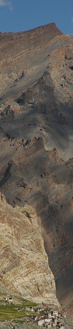
Two ways lead down the pass, Martin and I take the short-cut and slide down the steep gravel slope. Tripping not advised, the trail runs on narrow ridges quickly down to a fairly level ground where a good trail takes us to a mani wall and a chorten. From here we see the green fields of Photoskar and then the village itself. Just behind the houses rise the steep cliffs of the Zanskar range, a stunning contrast. From the right comes a creek, also muddy from recent rain. A bridge brings us to the campground next to the river. It was a long day in mostly hot weather, and after putting up the tent it feels wonderful to lie down for a few moments.
A cup of hot chocolate revives some of my energy, and Ger joins me for a short stroll to the village. The barley fields, white houses and reddish cliffs look fantastic in the late afternoon light and we prolong our walk down to the river. On the bridge's other side stands a traditional mill, and when we peak into it suddenly an old, dusty villager appears in its doorway. After a short talk further up we meet a group of elder women, first they are very shy but become very active when seeing themselves on the display of the camera. When another younger woman appears, who though without knowledge of English manages to translate my Tibetan into Ladakhi, the older ones become even more active and even dance with Ger.
The sun is setting, and the views up the valley are stunning; the silver creek meandering through fields of green where the hairs on ears are finely accentuated.
Just as the sun disappears behind the ridge, and we're almost at camp, out of nowhere half a dozen flock of sheep appear and are driven down to the village. Maybe we're lucky and meet them tomorrow morning on their way up.
But for now I'm very tired, especially after the additional side trip through Photoskar. A great, tiring day of trekking.
| Summary Part 2: We start in Panjila and follow a grey river upstream, then enter a narrow gorge where steep rockpillars rise high into the sky. The valley opens up and we arrive in Honupatta, a pretty village. On the way to our first pass, the Sirsir La, we leave the fertile valley behind and climb up the arid slope. From the top we enjoy the views of the valleys in stunning colours. Suddenly the arid high-altitude desert is interrupted; we reach the fields of Photoskar and marvel at the great contrasts: in the foreground the wide barley fields, perched on the edge stands the village with steep rockfaces rising above the whitewashed houses. |


