MyHimalayasimpressions from |
|
|||||||

Swampy plain near Dat, the village below the organ pipes is only visible because
of the red bushes drying on the roofs.

Monastery of Dat
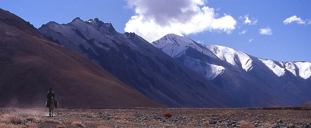
Nomad riding from Lungmoche to Dat.
High altitude plain on the way from Dat to Yar La. The rider on the right is
riding to Dat.
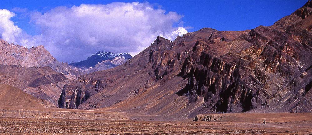
View back towards the Zalung Karpo La which we crossd two days ago.
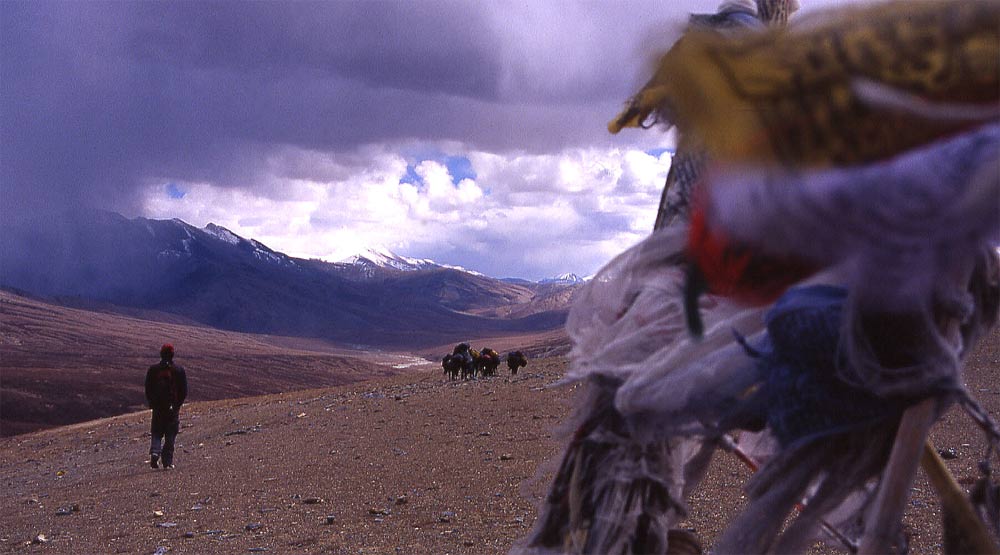
Descending from Yar La, another 5'000 pass. Bad weather is moving in but once
more we escape the downpour and only suffer cold temperatures.
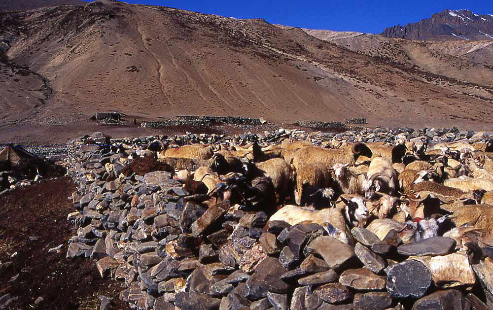
The summer settlement of Lungmoche consists of a dozen simple stone huts and
tents. Ladakhi keep yaks and sheep that are driven down from the grazing areas
at night and kept in stone walls to protect them from wolves and snow leopards.
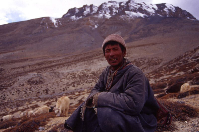
Shepherd watching his goat and sheep.
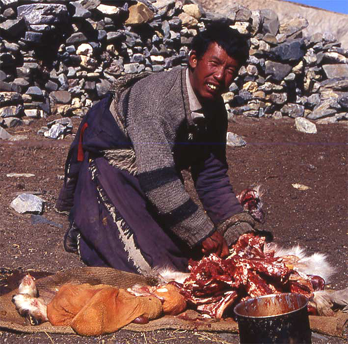
Yaks are rarely slaughtered, goat is available in abundance.
Another small pass between Lungmoche and Sangtha. At the horizon is Yar La which
we crossed the day before.
Descending to Sangtha in a fantastic canyon.
Pogmar is a Tibetan settlement and not inhabited in summer. At the lowest point
on the ridge on the left lies Yar La, the pass which separates this valley from
Dat.
Tso Moriri: Dat - Pang
Dat - Pogmar - Pang
Dat - Yar La - Lungmoche (Day 12)
The coldest night so far, the waterbottle froze solid. Little ice-crystals fall down my neck as I stretch inside the tent - still inside my sleeping bag. The sun hits the dining tent after the first cup of tea and we enjoy being warmed up while having custom-made omelettes.
The first part takes us across the swampy plain towards Dat Go (Head of Dat), the village half a mile south of our camp. Dozens of narrow but deep rivulets run through the yellow meadow. They are still frozen and make walking easy, soon I've crossed the plain and arrive at the village. From far away it looks idyllic between the golden meadow and the yellow washed out organ pipes, above them stretches a wide barren desert until a snowy range at the horizon. Once inside the village the garbage and waste of "civilisation" turn me off and I'm happy to be out in the plain above the river. The completely even valley floor is bordered by hills, the vastness feels great.
Fog and white clouds move in and out of the ranges to the right, large clouds have already built up above the cragged massif we came from yesterday. Above us is blue sky, increasing the feeling of walking in a desert. Not a bush, let alone a tree, is in sight. The two gullies I cross are dried out, but some one-foot high green bushes and tiny flowers survive there. The canyon walls to the left and the hills to the right feature some narrow animal trails. A cloud of dust approaches, in the exact moment I see the mounted horse two large animals shoot out from a little gully on my left, and quickly disappear in a hollow to the right. After my initial surprise I realise that the rider on his way to Dat scared up two khyang - the rare Tibetan wild ass.
A motorable dirt road has been finished recently and connects the valley with the Leh - Manali highway. Although we will not see a vehicle on our entire trek, just the thought of walking on a 'road' is making it less enjoyable. Of course local people's needs come first - especially before trekkers' wishes - but it makes me feel sad that after the next five years it will be hard to find remote trekking routes anymore. The valley with Yar La on its top is not that far away, but to actually see our destination from the flat plain makes it a very long and tiring walk.
I must be far ahead, nobody is following me so I sit down to wait in the shade of one of the mani walls which are built along the trail. A strange noise around me seems to come from nowhere, finally I lift my head and spot the large eagle that circles above me. After some more turns the large bird leaves. Through binoculars I see a herd of 7 khyangs across the plateau, and a larger herd below a slope. They perform some kind of mating ritual, two (males?) quickly gallop into the herd and drive it apart, then they run around them and further break up the party until they singled out a female. Hopefully we'll get a chance to watch the rare animals from much closer on our way to Tso Moriri.
I fasten my pace to catch up with Lobsang who went ahead with lunch. Soon he turns into a small black figure in the immense landscape. Suddenly he is gone. The trail leads into a sidevalley, and still neither Lobsang nor lunch are in sight. Im in desperate need for lunch, both for food and a break from the mornings monotony. At the foot of a cliff we finally rest.
This morning has been a slog with fascinating but unchanging scenery for hours. This will change, the road is still there but we will take a more direct route to the pass. At the foot of the pass starts a stone wall, two feet high but without any carved stones on it. It's not a mani wall but simply the trail for winter in times of much snowfall.
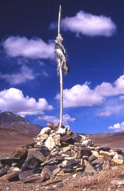
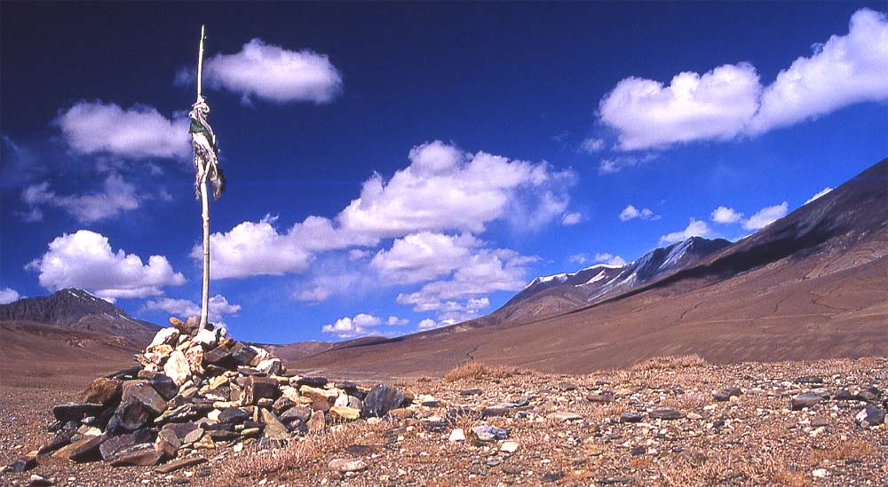
It is a steep, rewarding climb. A white chorten appears against the black sky, the cold wind blows scraps of dark clouds across the sky. Prayerflags flatter in the wind on the ridge. Crossing passes on nice days is pleasant, now the chorten against the heavy clouds and flags being torn by winds is more memorable, and increases the meaning of the monument. The mani stones are exceptionally beautiful, carved on reddish stones so similar to the ones at Lhatso that it's probably the work of the same artist.
Tenba and Phuntsok are already waiting and look for a sheltered spot. Our leadhorse arrives, Tenba the horseman adds a stone to the pile and continues to Lungmoche. Halfway down I meet a shepherd who watches his flock of sheep and goats. About one hundred animals graze between the bushes on the barren slope, but since the weather is turning nasty he also gets ready to go down.
Our campsite lies some minutes above the village, seeing how fast the snow-clouds approach increases the speed of putting up the tent. Eventually the clouds move on. Getting drenched, snowed in or staying dry is just a matter of two hundreds meters. Nevertheless, it stays cold enough to make any outdoor activity unpleasant and since it's getting dark I don't follow Lobsang to Lungmoche. He goes down to the village to fetch local specialities. Tenba uses the fresh yoghurt in a fantastic curry. Mixed with spinach and dal baht we enjoy another high-altitude feast.
Lungmoche - Pogmar (Day 13)
As the sun rises, the mountains glow orange and the sky is incredibly blue.
A yak herd is already on their way up to their pastures, two dozen animals plod up the slope. Teenagers drive five flocks of sheep and goat towards the pass, three groups are going down the valley. It seems that sheep is looked after by each family themselves. At night they bring back their animals and put them inside the stone cage as a protection against wolves and snow leopards. The women and kids milk the larger sheep, a tiring work for little amounts of milk.
I want to reach the village while people are still there and leave quickly. Few people live in the semi-permanent village, after seeing Dat and Dat Go I expected to find a larger summer settlement here. There are probably other settlements like Lungmoche in the area. People depend on their animals, yaks are most valuable and therefore rarely slaughtered. They are great pack animals and give rich milk, the vital meat supply comes mainly from sheep. Two families have slaughtered a goat this morning and cut up the meat. The husbands stay in the village with their wife, while their children have left the village with the flock. The young kids are outgoing to the point of rudeness, talking to their parents is more relaxed and interesting.
The gompa of Dat is being looked after by lay-people, these semi-monks are allowed to marry, and live lives like all the others. Religious duties in Dat require commitment and extra work, which less people are willing to do these days. I wonder what kind of support they get from their head-monastery in Hemis. That is the richest monastery in Ladakh, since it lies hidden in the fertile Indus valley and thus escaped pillaging invaders.
On the trail we pass a few mani walls on our way to an unnamed low pass that separates Lungmoche from Sangtha. The slopes are barren except for some low dark green bushes, the reddish hills follow each other in an endless succession. Once you know the path that connect the villages, the territory seems less threatening. Yet the first explorers probably not only had to cope with enormous physical hardships, but also with worries and disillusion as they wandered in barren deserts for weeks on end, not knowing when to reach the next settlement. For us it is a straight-forward walk towards the isolated pile of stones with a simple prayerflags on top, knowing that in some hours time well find shelter. This pass is either considered not important or not travelled often.
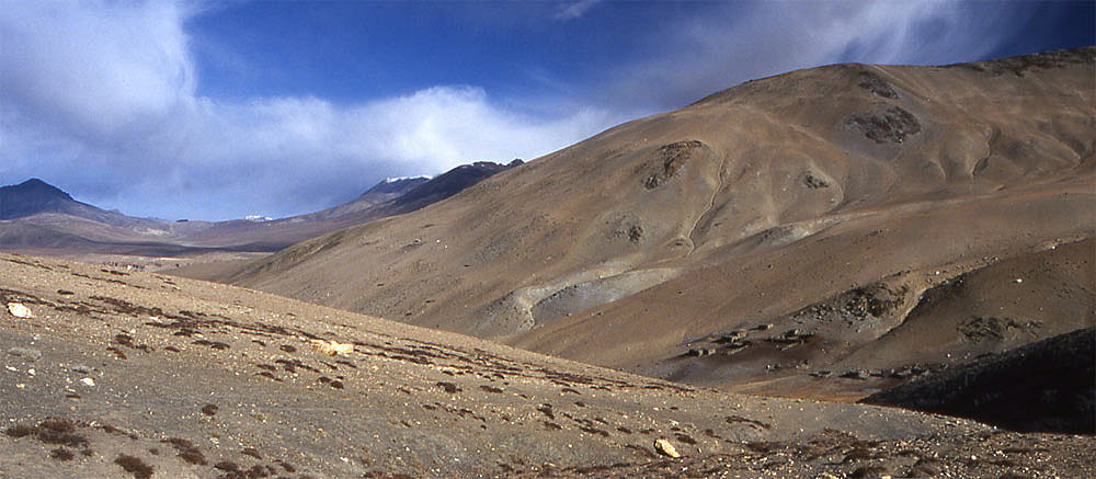
We look into another valley, yellow stone at its bottom but the colour gets darker higher up and the top at the horizon is formed by black rock mountains. Suddenly we drop into a gorge that could be near Lake Powell, and not the Himalayas. The red cliffs have bizarre holes and cambers. A fine place for lunch.
The bottom of the valley is completely flat and must have been covered by a huge river or glacier ages ago. A storm looms over us as we wander across the plain, fighting against a strong wind that, to my surprise, carriers neither dust nor sand. Just before the plain gives way to hills, a dried out riverbed lies ten meters below us. At its bank are a dozen simple stones buildings, not as simple as Dat or Lungmoche, but neither as homely as Hankar. This is the village of Sangtha. It is abandoned now, only the spread-out yak dung indicates that people come here in winter to spend the cold months here. The chortens across the river are outstanding, almost a dozen whitewashed monuments are grouped together and connected by a mani wall.
Like the other villages so far, this is also a Ladakhi village. Our camp lies higher up, near one of the few Tibetan settlements. The grazing rights are strict, the Tibetans are not allowed to come down here. They graze instead in the other direction. I wonder how much interaction is going on between the villages, and if they're always on a friendly basis. Especially after too much chang, discussion can be strong, I've experienced.
It is more tiring walking uphill, the horses have passed us and become smaller and smaller in the distance. The scenery is great, hills in all colours gently rise above the plain, and the wind plays with the clouds and arranges them in all kinds of shapes.
I hoped to find a nice and lively Tibetan village. But it is not that different from the Ladakhi villages, presently dilapidated and abandoned.
Shortly after arriving I decide to get a complete wash. A pipe collects the water from a spring, some puddles have turned into ice. Nevertheless I manage to get a good wash, freezing vital organs only temporarily. It feels wonderful five minutes later with clean clothes, lying in the sleeping bag and warming up with a hot chocolate. A hot footbath does wonders, the two blisters that have emerged are gone for good.
Temperatures are not as cold, though something makes me sleep less well than the nights before.
Pogmar - Pang (Day 14)
Early start for everybody, we should get to Nabru on time to catch the jeep that takes us to Pang - walking the four hours over the plain next to the concrete road wouldn't be fun. Only one more pass and the first part of the trek will already be finished.
The trail branches off and we climb on a flank away from the broader trail. The hillside shows the typical marks of goat traffic, numerous trails that seem like steps on a pyramid. I can only imagine how green and different it all must look in summer. What looked like chorten is a natural pile of rubble on a little summit. The views towards where we came from show immense scenery; gentle hills don't block the view over the endless vastness. As we get to the natural chorten, we turn left and climb up higher. A new range appears on the right as we start traversing the hillside. Lobsang ran after Bob who took the broad trail, I'm not sure I am on the one that Lobsang suggested but the general direction seems ok and even if we're wrong the crew behind us will point us to the right direction. Soon everybody catches up and together we walk towards the pass that is soon visible. Two piles of stones with prayerflags between mark the end of the trek - luckily just the end of the first stage.
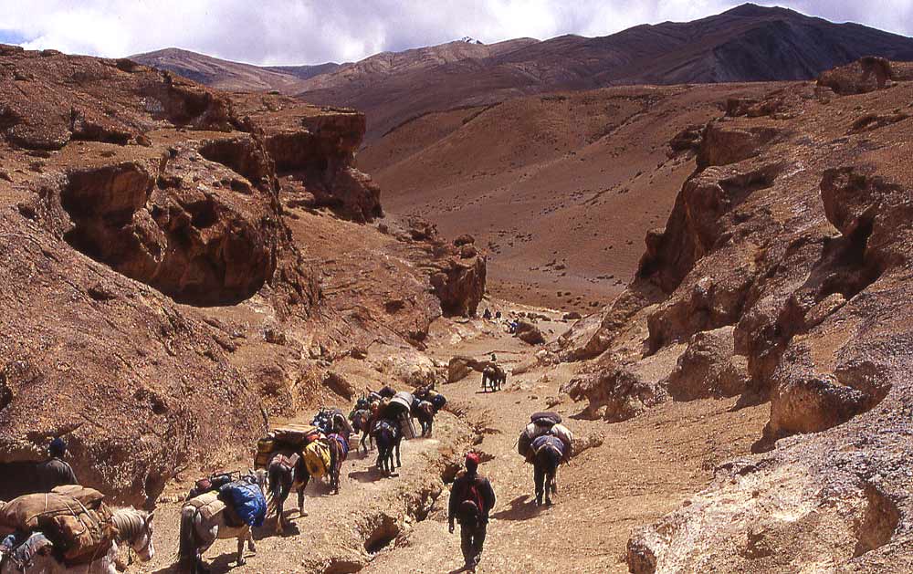
Below us stretches a wide valley, enclosed by snow peaks, above which sunshine and a local storm seem to fight over air supremacy. As striking as it looks, I'm happy to see the dustcloud of a jeep approaching which means I can give my feet some rest and enjoy the short drive to Pang. Wangchuk is waiting and greets me with his wide smile, and then we're on one of the most spectacular roads on earth. The black tarred road is a tiny line in this grand landscape where empty barrels of tar are put up every hundred meters to mark the road. Only a few orange Tata trucks are on the road. At the end of the plateau Wangchuk stops, below is a large canyon in which we'll camp tonight after a short hike from Pang. It is a few more minutes on the serpentine road to the 'town' that is less disgusting than I feared. Army barracks form the one end, a dozen parachute restaurants the other. The Indian army uses huge cargo parachutes, once they're too old for dropping supplies; locals use them as tents and install a shop and restaurant inside. The white cloth keeps the dust and heat out and makes it pleasantly bright inside.
The major road to Leh passes through Pang (the one from Srinagar passes through Kargil and is 'artillery-prone') and the tourists and army generate enough business for the Ladakhi women running the shops. But here, like elsewhere in Ladakh, they complain about bad business.
Jamie should be waiting here with fresh supplies, and a fresh trekker. Malc from England arrived some days ago in Leh and will be on the climbing part of the trek. A great guy, somehow all the Brits I've been trekking with were fun. Nicole will leave us here after having trekked for more than a month. Everything goes smoothly, Jamie really did arrive with all the supplies the day before yesterday despite a motor ralley in which only 20% of the cars arrive at the destination (it's probably a good idea the road was closed for other traffic that day!). We have a hot noodle soup, Tibetan tea, and buy all the remaining soft drinks and chips. Soon the horses are here. Reloading takes some time and I enjoy a nap. In the late afternoon we're ready to start.
The security in the army camp seems lax, we just walk through the barracks to get down to the valley floor. Im pretty sure if you would do that in western Jammu youd be shot without warning. An officer gets off his chair and looks at us for a few seconds as we walk down to the river. Jumping across the few spots where the water level is deep isnt too difficult. Strange rock formations watch down on us as we continue up the river in search for a suitable campsite. Strangely the horses haven't caught up with us, after some time Jamie walks back to Pang to check if everything is ok. I assume Tenba knows the restaurant owners and after packing the horses went to chat a little. It's very windy and cold, I'm looking forward to my down jacket that arrives twenty minutes later on the back of the horse. Tents are set up quickly, hot soup and dinner mark the end of another good day that wasnt marred by the stopover in civilisation.
|
Summary Part 4:
After leaving Dat we temporarily leave mountain scenery and walk over a wide plain until we arrive at the foot of Yar La. A white chorten appears against the black sky, the cold wind blows scraps of dark clouds across the sky. Prayerflags flatter in the wind on the ridge. Crossing passes on nice days is pleasant, now the chorten against the heavy clouds and flags being torn by winds is more memorable, and increases the meaning of the monument. The storms spares us once more. We leave the village in the morning when the nomads leave with their sheep and yaks for the surrounding barren meadows. |
||
| (c) 2006, Carsten Nebel |