MyHimalayasimpressions from |
|
|||||||

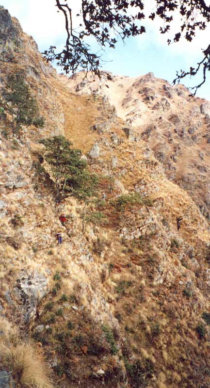
Exposed trails in dense forests run high above the deep gorges and valleys, this
is the most exciting bridge during the whole trek.
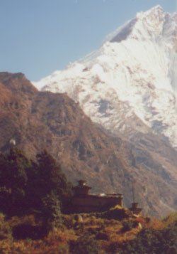
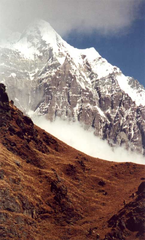
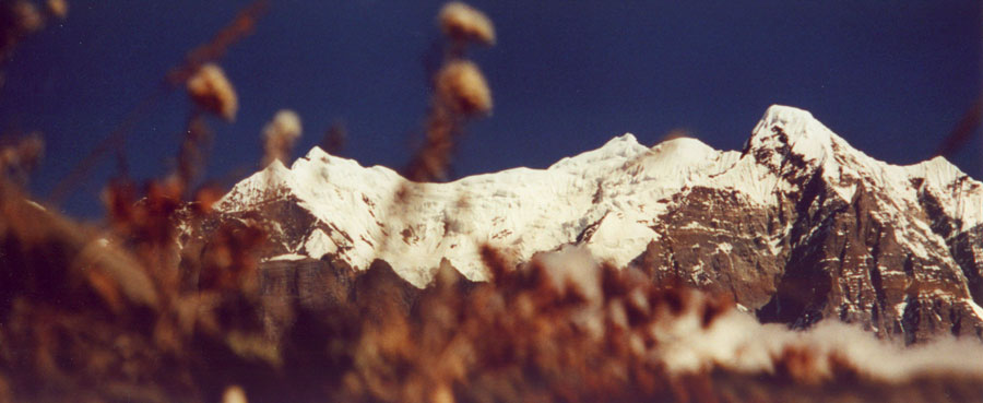
The steep glacier from Ganesh III is just one of the many impressive mountain
views on our first day in the high country.
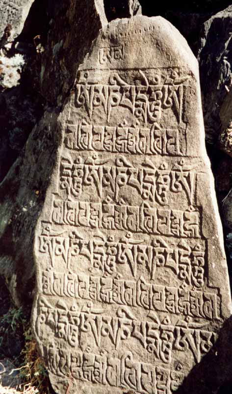
Like in most parts of Nepal, the regions in the north are almost completely
Buddhist. Carved stones with mantras and prayers are the first obvious sign of
meeting with a new culture.

Old scripts tell of worthy deeds of early and famous lamas that lived in the
area. The famous Milarepa is believed to have spent some time in Tsum.

Padmasambhava brought Buddhism to Tibet. The founder of the Nyingmapa sect is
very popular, paintings and statues of him are very common in this part of
Nepal.
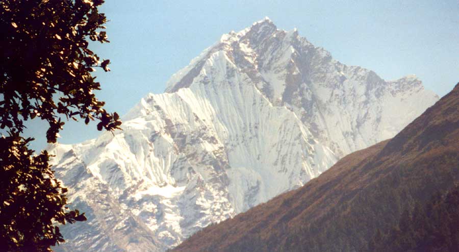
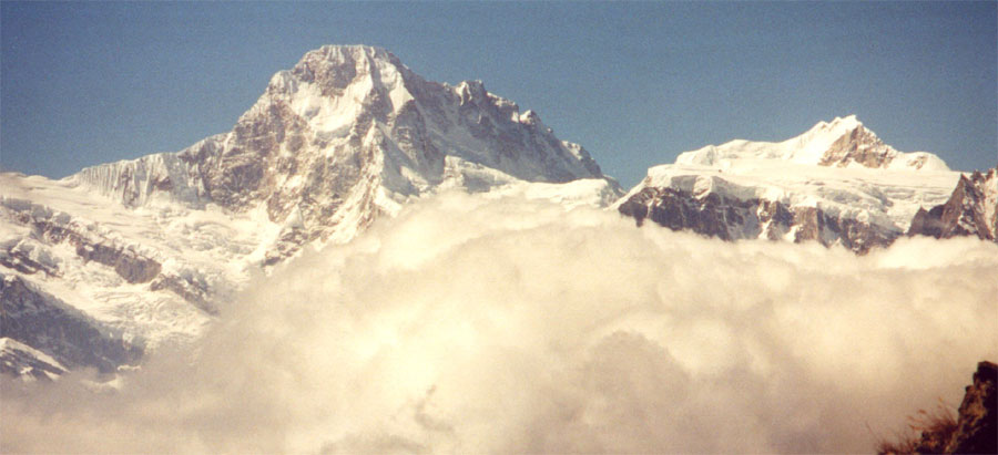
The impressive west face of Ganesh I (7'406 meters) from the trail to base camp.
The steep hike from Domjet is rewarded not only by fantastic views of Ganesh and
Himal Chuli, but by a nice village high above the river.
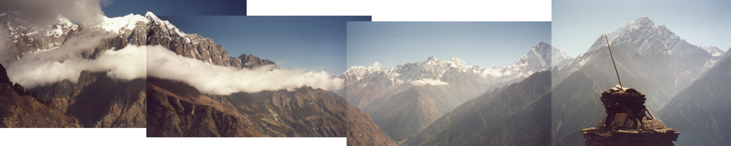
The southern end of the Tsum valley lies between two ranges of 7'000 meters, the
northern end stretches deep into Tibetan (Chinese) territory is more flat and
part of the high plateau. This a view from the spectacular high traverse towards
Nupri.

Lizzy, John and Jamie posing.
The colourful fields and villages high up on the steep mountain flanks make the
traverse below Shringi one of the highlightes of our trek.
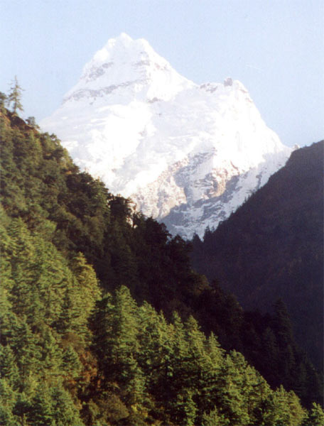
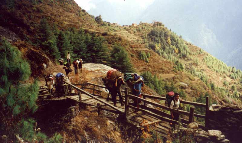
Porters taking the steep trail, the sheer rock face of Shringi Himal is just
coming out of the morning fog.
It is not exactly rockclimbing, but the trail does require to hold on rocks and
bushes. And it is steep.
Some tricky spots and long days can be expected on that trail, but it is
absolutely worth it.
Himal Chuli, gigantic peak next to the Manaslu range.
Manaslu:
Lukawa - Tsum valley - Bim Phedi
Lukawa - Domje (Day 7)
The morning is spent walking through the dense forest, which would be nice but I am really longing for open spaces. After crossing two creeks we pass through a very narrow gorge and then start climbing up again. Shringi Himal is close now and a good reason to walk up this hill, knowing (or better: hoping) that this is the last obstacle before a wider valley makes every step less strenuous. The trail is not used often and the porters with the bulky load have to clear some tricky spots.
The river is hundreds of feet below us - but it does not provoke any concern, some even enjoy it. It is touching to see how an older couple, nicknamed Mr. and Mrs. Jones, take care of each other. They live as farmers near Arughat, but because monsoon has destroyed many of their fields they are out of work. They probably won't come all the way with us, I really, really like them and though they speak no English, I often stop when they take a break and share some snacks with them.
The views of Shringi and the Ganesh range are a well-deserved reward after the hard morning, but we still have a long way to go for our lunch spot.
The trail drops down to a bridge, then goes all the way up again. Luckily the bridge is built very high above the river, so we do not lose the entire altitude gained since the morning. The kitchen crew is already far ahead (or more exactly: far up), after a short break in the sun I climb the hill in a relatively short time. It is assuring to know that I am getting in better shape from day to day, and my knee seems fine.
When I reach the first chorten with fine paintings on the ceiling, I am both excited and very happy. Many small settlements are spread on the whole valley side, topped by mountains on all sides, with the carved mani stones in the foreground it is an amazing view. I don't spot the kitchen crew anywhere and just walk on, counting on them calling me when they see me walking past them. I find them near the creek where large boulders are a good place to warm up again after a refreshing wash. While having lunch, I enjoy the fantastic views of the mountains. The icefalls, glaciers and ridges leading to the summits seem like delicate works of art. Bringing binoculars was a good idea, though it makes me wish I had a much, much, much bigger lens and good filters for my camera.
Most villagers are in the fields, harvesting the last yellow barley, the towns are empty. We stay north of the river and continue our traverse upstream through fragrant pine forests. Monkeys are fleeing from tree to tree, it is a good thing they do not display the same attitude towards tourists as their aggressive relatives in Swayambunath. Soon afterwards I get to enjoy the hospitality which makes travelling in the Himalayas so amazing: locals are taking a break from cutting grass and invite me to join them for lunch. I decline their tsampa and buttertea (in this case more because of well-founded stomach-paranoia than because of being full, I feel hungry again soon after a meal) but sit down to have some of their popcorn and a little smalltalk.
Some porters passed me and when I catch up with them they point to the trail, so I descend to the river and cross a landslide that killed three people, many yaks, wiped out some houses and destroyed the best farmland in the valley. As it turns out, the porters showed me the wrong trail and take another one. Luckily the two brothers from Chokang that we met at lunch are also going the faster lower route, and soon catch up with me. The older of the two works as a teacher in Chokang and walked to Arughat to pick up his younger brother who studies in Kathmandu. They have to get to their village tonight and I have to hurry to keep up with their pace. I am a bit worried when we walk way past Domje and they keep repeating that there is a bridge further up. Eventually we really get to a bridge. When I offer a pack of cookies for on their way they decline and seem to feel a little insulted. They say 'it is brotherhood of man, we have to help each other', but when I insist that the biscuits are not a payment for anything but a gift, they accept it.
It takes a long time, but finally Manjul and Tenba descend from the high trail and cross the very, very shaky bridge. Taking picture of people's faces during and after crossing it would have been highly interesting. This is not to say that I looked better when I crossed...
None of us, including the crew, were here before, it is good that the two guys explained the way to the Domje bridge, it is not easy to find because the small trail in the high grass and bushes is hard to spot. We cross it near 'the blue lagoon', a beautiful spot with the blue river, steep rocks and colorful trees. The water might be a little colder than on the Maldives, but it looks the same. The flat fields around the village have been harvested and are now used to keep two dozen yaks and dzos.
Foreigners are an attraction, the people are rough but friendly and some of the kids are extremely shy. I don't know if that is a good sign, the last foreigners that camped here went missing, they were probably killed by an avalanche near Ganesh.
So far we have never used the dining tent, but now temperatures are getting chilly. This will probably be the last dinner under a clear sky. It was a long and strenuous day, and after a filling and tasty meal I go to bed early.
Domje "Restday" (Day 8)
Since the schedule would be too tight, we can stay only one more day and have to start towards Nupri tomorrow. There will certainly be more things to explore in the next three weeks. It is hard to decide how to spend the one precious day, I could either go up the Tsum valley to Chhekampar or walk towards Ganesh basecamp, with an interesting gompa halfway there. In retrospect I should have set out for Chokang, with an early start and some luck at the checkpost I might have gotten far north.
Instead I walk up the hill towards Ganesh. The discussion with the village headman, a quite strange guy, takes some time; he wants money for nothing but then we get a guide to take us up the confusing trails. It is a long and steep climb at first, when we leave the forest it flattens (relatively speaking) and becomes a gentle walk through high yellow grass..
The vistas become better and better, straight-ahead is the steep icefall of Ganesh I (7'406 m), to our right are Ganesh III and Ganesh IV. The valley we walked up yesterday looks tiny now, the deep gorge is just a small trench in the terrific landscape. Himal Chuli (7'893 m) is dominating the scenery to the west. As we walk up higher the mountains become more impressive. The river is far, far below, walking on the small path requires some attention but is not dangerous at all.
On a gentle slope stand some simple houses, colorful trees and bushes surround the town. The ice and snow of Ganesh I in the background make it by far the prettiest village so far. Just this view alone is worth the two-hour climb. Somewhat below is the monastery that is being rebuilt after it was destroyed by fire. Who knows, maybe it burned down after some tourists visited and the locals are afraid that there might be a connection between the foreigners and the destruction. In Domje the headman was persistent that we do not take any pictures, not even of the area. A small building contains the statues and paintings that will be moved back to the lhakang later, the paintings on the wooden panels look really nice. There are three really old gompas in the area, two of them further up in Tsum and then this one here. I assume there is another monastery in the village, three nuns are in retreat for one year and do not meet or speak to anyone during that time. I am surprised not have found any reference to the monastery in any book, on the map it is named Toro Gompa.
The views are probably even better from the grazing area a few minutes further up, but I am completely satisfied and head back down to camp after spending some more minutes at the monastery. Like on previous days, clouds start moving in during the afternoon, thus making Himal Chuli even more impressive as the flat glacier slowly disappears in the clouds.
The others who went to Chhekampar had a great time. The trail climbs steeply but the views of the all the mountains forming the border are worth it. Only few tourists visit this valley and locals are very friendly, though their buttertea was not enjoyed that much. I guess I should go for the village option the next time I can chose, but the gompa was a nice sidetrip, too.
Domje - Shringi traverse (Day 9)
Our toilet tent disappeared! It was probably taken by some Tibetan villagers from further down, between 130 and 200 at night. We met a group of climbers in Philin who had their whole advanced base camp stolen a week earlier, they caught a boy and brought him to the police station. There he will probably be beaten until he blurts out the name of others, but the equipment will probably not turn up. So we were lucky just to lose our toilet tent.
We are now trying to get back to the main trail towards Larkya La on a high route below Shringi Himal. Nobody could tell us how long it would take, so I get ready for two hard days. 'Getting ready' sounds very serious, yet it simply means putting extra rations of snacks in my daypack. I start a little earlier to visit Kowa village, but it proves an unnecessary detour because a large prayer wheel is the only thing of interest there. Soon afterwards I have crossed the unstable bridge and am back on the main trail. After two minutes I figure I am on the wrong path and turn around to go zigzagging up the hill just opposite the campsite. Passing some porters on the way up assures me of the correct trail.
I take off some clothes as the sun and the climb make it quite hot. So far I have always found a good balance between 'freezing for a few minutes' and 'not having to carry much clothes in the backpack', but I guess it will become more difficult higher up.
The walk through pine forests is very relaxing, especially when the trail becomes more flat. I have to drive away some yaks on their way to the grazing area. Their horns are dangerous and even the Sherpas show much respect when they get too close. Two large raptors circle above us in the dark blue sky, gliding in the wind without moving their wide wings a single time.
The mountain views are stunning again, though I would not mind the range being a bit less high so we could get a glimpse of the Tibetan high plateau that starts after the Ganesh range. As we climb steadily but not very steeply, the large number of settlements above us surprises me, they were not visible from the bottom of the valley. Far below is the lunch spot of two days ago, even the bridge across the stream is visible. The village Richet looks very interesting from high up, the three dozen houses all stand on a small ridge, only two chortens were erected on the plateau, thus saving all the land for cultivation. Supposedly the monastery features nice paintings on old wooden panels.
After walking for half a day without passing through a village, water-driven mills announce a welcome change. I give up plans of exploring the village after a small dog attacks me. Two old ladies grab their pet and assure me that it is safe now, but I can see and hear the next dog already.
I did not look at my map closely enough to see that there is a deep sidevalley to cross in order to get to Nupri. To look all the way down to our potential campsite and all the way up again on the other side (tomorrow's walk) is not exactly heartbreaking, but it does hurt to lose all the altitude. After a filling meal of peanuts (courtesy Jamie McGuinness), we walk down the steep, steep trail towards the river.
There is one suitable spot for putting up tents in a small dried out riverbed. The water in the main river is full of sediments, but a small creek with clear water makes it a decent campsite. The girls from the nearby village make the campsite acceptable to our porters, too. I feel a bit bad for the porters, they try flirting, giving nice compliments and later suggestive jokes, but they are just ridiculed by the girls, though I guess they do find it at least a little flattering. So despite the hard day everybody is in a good mood.
Shringi traverse - Bim Phedi (Day 10)
This is the second day of our 'high trail to Nupri' exploration. The traverse yesterday was just amazing and will hard to top. Locals said it would take us 6 hours to 11/2 days from here to the next village, so nobody knows how long it will take. This trembling uncertainty is a good excuse to bring even more snacks than yesterday.
What should have warned us of the things to come is the fact that Jamie takes out the Choco flakes and real muesli for breakfast. After this treat we try to find out which trail the porters took. The first two hours will be steep uphill walking, that is for sure. We packed early so the crew could go ahead, and after some minutes I spot the last two - Mr. and Mrs. Jones - way above me. There must be a trail somewhere but I go for the direct route and soon catch up with them. As we get higher, more of the valley is revealed. The clouds in front of Shringi Himal are dispersing just in time to unveil the steep rock faces, icefalls and glaciers. What I took for the final ridge is of course not the final one, but at least we are above the highest point of yesterday and rewarded by interesting views all the way up the valley. Red and yellow trees and Shringi make it even more interesting. The whole Ganesh range is to the right, but the sunlight blurs the details that make the mountains so exceptionally beautiful and seem to give them even some kind of personality.
The trail is slowly disappearing in the yellow grass, the silhouette of chorten high up indicates a landmark which we probably should not miss. There is some confusion about which trail to take, two people almost got lost further down and keeping the group together is not that easy. With some yelling and waving everybody is on the right 'trail' and climbs the steep hill. Two incentives make regular stops enjoyable: 1. the fantastic views, and 2. the hard climb at relative high altitude. Admittedly, the order might be the other way round.
But eventually I get up to the chorten, it was a fantastic climb with an even better vista: Himal Chuli and Boudha Himal to the southwest, Shringi to the north and Ganesh on the opposite side of the valley that stretches far northeast. Settlements and their fields cover most of the northern valley wall that looked much steeper from the bottom. The mountain pasture we just climbed is steep, and the other side of the ridge is a vertical barren face, for a moment I feel rather uncomfortable. I was fine when busy walking, but now there is time to look around and realize how high up we are. Not that there is any danger, though with snow or lots of rain it might be risky taking this trail, but I just don't like heights very much. After a relaxed break with tea and chocolate I feel better and fully take in the great surroundings.
Some are sweating more than others, but everybody makes it, even the porters arrive just a few minutes later. After the well-deserved break we continue our climb, after reaching the second chorten we set out for the traverse towards the Nupri valley. We descend a very steep gully and are zigzagging down, trying not to send fist-sized rocks thundering down but occasionally it is necessary to run a few meters for a safe spot. After resting on another ridge and another steep descent the trail changes. So far it was only strenuous and steep. Now it also becomes tricky, narrow rock ledges where some parts require balancing and holding on to the wall make it very exciting. I am stunned to see how the porters cope with this, at one spot the kitchen boy has to try several times to find a way around a difficult corner where his basket gets caught on an overhanging rock. Eventually we reach a spot wide enough for a dozen people to sit down and have lunch.
Every time I think the views cannot get better they do: Boudha Himal, Himal Chuli and the wide glacial valley are 15 miles away. We got here just in time, a few minutes later fog moves up fast, hiding most mountains. A nameless peak of the Lobche range just across the valley is hiding and re-appearing out of the clouds, changing its appearance every few minutes depending on the cloud cover.
After lunch the traverse becomes easier and we soon get to the final bend before entering the main valley to the west. A wildfire destroyed most of the pine forest; far away some high peaks of the Kutang Himal rise above the charcoaled trees. Looking towards south we spot Lukuwa, Eklabhatti and Philin - villages we stayed at a week ago. I expect a gentle downhill traverse to the campsite from here on. I am wrong. The trail is easy at first but then we get into underbrush and increasingly wet and dense forest. Bharat just loves it, every time when his laughter gets louder you can expect steep muddy parts where you have to grab some bamboo, or other difficult obstacles. We climb over dead trees, crouch beneath dead trees, climb down rocks and slip in the morass. One spot requires climbing down a notched trunk for a few meters. After some more exposed spots we can relax a little and fully enjoy the hike just above deep valleys. Despite our efforts the terrain has slowed us down, two hours later we can still see the charcoaled forest. There will not be any villages or campsites for a few more hours, and since we are running low on food our crew is hurrying and far ahead of most tourists.
It is the first time I walk with Bharat, our sirdar. The porter problems kept him busy the previous days, now he is more relaxed. He is very funny guy without being cocky. His saying 'Same same but different' quickly becomes a favorite amongst us. The Manaslu Circuit is well-known to him, and though he has done it several times he is still curious enough to walk around in the villages. His (not serious) attempts at matchmaking will not be successful, but this doesn't make the time spent near the kitchen fire with local girls any less memorable.
After getting out of the forest we reach bright green wheat fields and a few houses, all of them deserted. I am surprised that nobody is watching the fields, a large group of Langurs is fleeing from us but will soon be back and enjoy the grain. Tom and I follow Tenba, assuming that he has received instructions from Bharat and knows where to go. From the ridge we look into the Nupri valley and some 'smaller' sidevalleys. I stop for a minute and suddenly everybody has disappeared. I pick one of the trails branching off where I imagine to see familiar boot prints; luckily after some minutes descending in the forest I catch up with Raju, a kitchen boy. It must be late afternoon already and the prospect of walking in the dark is an incentive to increase my speed - I am running down the hill. Nevertheless, I reckon it will be dusk before we get anywhere. After ten minutes I am at the bottom of the valley, resist the temptation to fill up my water bottle in the creek and content myself with a refreshing face wash instead.
Then it is up another hill on a neat trail chiseled in a steep rockface. Tenba is far, far ahead but I caught up with kitchen boy Tenzi on the way down and can keep up with him. I am really glad about all the snacks I am carrying today; we enjoy lots of calories while waiting for Raju and Tom. Sherpas are a proverb for loyalty and discipline, and I think Tenzi would have rather walked half-starved than eating any of the biscuits from the kitchen-basket he is carrying.
Through binoculars I spot Manjul and somebody else near the wheat fields, they are taking a strange trail leading right towards the steep cliff. There is nothing I can do but hope that they will find a better trail soon.
We continue down towards the Buri Gandaki, this should really be the last descent for today. I am starting to feel a little tired after ten hours of walking. Just before dusk we get to three simple houses near the river where Tenba is waiting. He wants us to go on because there is no food or even space for tents at Rana. I am fine with walking for another hour and we continue, increasing the speed, trying to reach Bim Phedi (also called Bihi) before it gets really dark. One part is a bit difficult without flashlight and I almost slip, but apart from a small scratch on my hand we arrive safe and sound and are greeted by Tenzing's laughter.
After drinking 2 liters of mineral water, eating some snacks, a complete wash with cold water and another snack I feel surprisingly fit. My mood has not suffered either, on the contrary. And thanks to the reunion with our sorted out gear from Jagat I even get to put on new clothes. A fresh shower and new clothes are more relaxing than two rest days.
Jamie is not in such a good mood when he arrives half an hour later; Tenba should have waited at the first possible campsite since not everybody will be able to make it to here. Tenzing sets out with some food for them. Most of them and porters get here an hour or two later. Their moods are very different, but after spending ten days together it is possible to guess how people feel and treat them accordingly - thus preventing any arguments or fights that could easily arise after such a day.
|
Summary Part 2:
One week after starting in the lowlands and then walking in the narrow valley of the Buri Gandaki, we finally reach the (relatively) open spaces of Tsum and get fantastic views of the mountains. The Ganesh range and Shringi Himal dominate the scenery with their size, though the Buddhist villages with their great stone carvings, chortens and paintings are equally stunning. During an extra day we explore the way to Ganesh I basecamp and the villages further up. Taking the high route towards Larkya La takes two tough but very rewarding days - not recommended to the squeamish or the weak-legged. The traverse offers terrific views not only of the mountains to the north, but also of Boudha Himal and Himal Chuli. The last part of the trail before reaching a village in the main valley is less exposed than others, but the terrain is very difficult and tiring. |