MyHimalayasimpressions from |
|
|||||||

Annapurna range with Machapuchare from the airplane.

After some minutes Dhaulagiri appears.
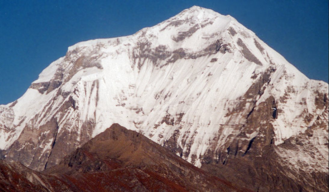
The 8'000 meter peak dominates the range to the west, several routes lead up
on the steep south face to the summit 8'167 meter.
We land in Jomosom, three hours later we approach the village Kagbeni, it
protects the entrance to Mustang. In earlier times as a trade post, these days
as a police check post that checks the trekking permits.
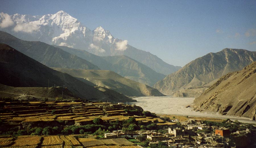
Overlooking Kagbeni and its red gompa, the north face of Nilgiri serves as a
barricade against monsoon clouds - Mustang is one of the few destinations which
lies in the rainshadow and makes trekking possible in summer months.
Upper Mustang: Pokhara - Jomosom - Kagbeni
Pokhara – Jomosom – Kagbeni
Pokhara – Jomosom – Kagbeni (24. August 1998)
Finally the first day of trekking starts. Walking to Jomosom would be a nice hike with great views of the Annapurna range, we cut that down to 30-minutes flight. Since heavy winds make flying in the afternoon impossible we’re at the airport really early. It’s so cloudy and foggy that we have to wait for awhile and when we finally take off I’m partly happy - because the flight was not cancelled, something that happens quite often - and partly disappointed. I’ve been looking forward to that spectacular flight and now I can’t see a single mountain...
Two minutes later we’re above the fog and have the whole mountain range in front of us with Dhaulagiri to the left, Annapurna, Fishtail and Manaslu to the right. What a view! We‘ve barely left for trekking and have the first highlight already, I hope we’ll be as lucky for the rest of the trek. Soon, much too soon, the plane starts descending after just 30 minutes of flying, the location of the airport is a mystery, until I detect a cleared piece of flat land. The airstrip lies in Jomosom, the main village in the Kali Gandaki valley, between two 8'000 m peaks.
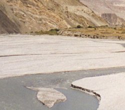
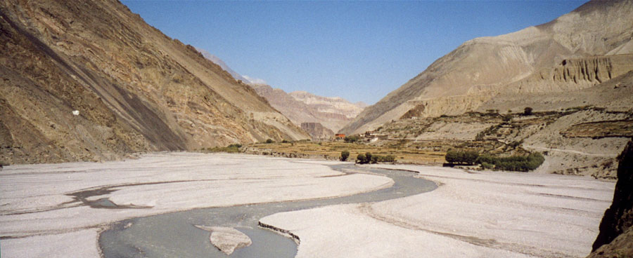
Soon after landing we meet some of our guides and start walking to Kagbeni, which is about 3 hours north and today’s camp. The fresh mountain air and comfortable temperatures are wonderful. We follow the river and walk in its bed which is fully filled during monsoon time in summer but a mere rivulet now. Every few minutes I turn around to see Nilgiri and Dhaulagiri whose glaciers shine in the morning sun high above me. It’s a sharp contrast to the canyon-like, barren area we’re in now.
In the far distance the red monastery of Kagbeni is a familiar sight – I’ve seen it four years ago on the Annapurna Circuit trek, it seemed like a gate to a forbidden and unknown place. Which it is, it’s the entrance to Mustang, the 'Forbidden Kingdom'. The rejective landscape north of it fascinated me back then already. 'What is hidden in this desolate area?' is asked myself. And now, a few years later I will find it out.
We’re a group of ten people, eight from Switzerland and two Nepali women; Sabita who is a partner of Regal Excursion, and Nima, the other partner’s sister. Matthias is our guide, though on the trek our sirdar Tenzi is in charge. Our group has spent the last few days together and Charles, Alexander, Margreth, Jeanine, Tina and Beatrice are nice and easy to get along with, hopefully it will stay this way. Our liaison officer, a professor working for the interior ministry, has kept to himself so far. Tenzi is our sirdar, Tenzing, Kami and Milan are sherpas, the cook is called Chiri. They are all from the same village in the Everest region. Two porters and a horseman also come with us.
I feel very more and more uplifted with every step that takes me closer to Kagbeni. It stands above the river and blocks the way towards north. 'Kag' means 'boulder', 'beni' is the word for the confluence of two rivers. It is the border to the Tibetan speaking, strictly Buddhist area in the north. Not only culturally, but also politically has it been independent from the 15th to the 18th century. Before that time it was part of West Tibet, afterwards Jumla conquered it but gave it much autonomy, which Mustang has kept to a lesser degree up to this day. The corn, barley and potato fields that surround the village can already be seen. It is charming, its houses are built in the style predominant in most areas north of the Himalayas; two or three story buildings with whitewashed walls and flat roofs where firewood and hay is dried for winter. Prayerflags flutter in the strong wind. I’m surprised to find quite a few guest houses and kids who ask for 'school pen, rupee, sweet'. This is the last village that can be visited with the Jomosom permit and probably the number of tourists who visit Kagbeni is simply too high. On the way to the monastery we pass a chorten, a building symbolizing the aspects of Buddhism and a welcome sight to weary travelers since it often announces a village.
This is the first monastery we visit, it belongs to the Sakya sect which is predominant in Upper Mustang. An earthquake has damaged the building and a new one is being built. When it is finished a lama will be invited to live and teach in Kagbeni and the monks hope it will attract other monks and revive Buddhism. That seems necessary, it is strange to see most villagers walk around chortens and mani walls not in clockwise direction but in the most convenient one. Many old traditions are still being followed but the importance of religion seems to decline. Monks are holding a ceremony for a protector deity and men could go and watch, but none of us wants to disturb them.
I set out for a walk in the fields outside the village where I enjoy the quiet late afternoon atmosphere and the nice views over the village. Haze lies before the peaks in the south, the ears on the fields glow in a warm golden light. The houses are built very closely to each other with small alleys leading to their doors, giving the impression of a maze. Except for small children and some older people the town is empty. Before dusk rush hours sets in, all the villagers are coming back from work. Men and women return from their fields, children drive the cattle, mules and goats from the grazing grounds. They have a lot fun, yelling at their animals and riding (or more accurate trying to ride) everything from small cows to goats. What strikes me is that work and fun are hard to separate, that people combine the two, something I’ll see more often in the next two weeks.
It gets dark fast, once the sun sets temperatures drop quickly and soon afterwards it is dark. We enjoy our first dinner in the kitchen and living room of a local family. Since it is not my first trekking I am not surprised by the huge quantities of delicious food, but some of the others seem to have expected a more ascetic life on the trek and are happy that this won’t be the case, at least dietary-wise.
|
Summary Part 1:
After the usual two days of sightseeing in Kathmandu we fly to Pokhara, a pleasant relaxed city west of the capital. Instead of walking from there to Mustang we take a 30-minute flight which is absolutely spectacular, two 8'000 peaks and dozens of smaller but not any less impressive summits rise into the sky. From Jomosom on we walk half a day to Kagbeni, it feels like being on a different planet. Instead of lush vegetation the scenery is defined by wide deserts and canyons. The next day we continue to follow the wide Kali Gandaki northwards. |