MyHimalayasimpressions from |
|
|||||||
Steep mountains beyond Bimthang get the first sunrays in the early morning.
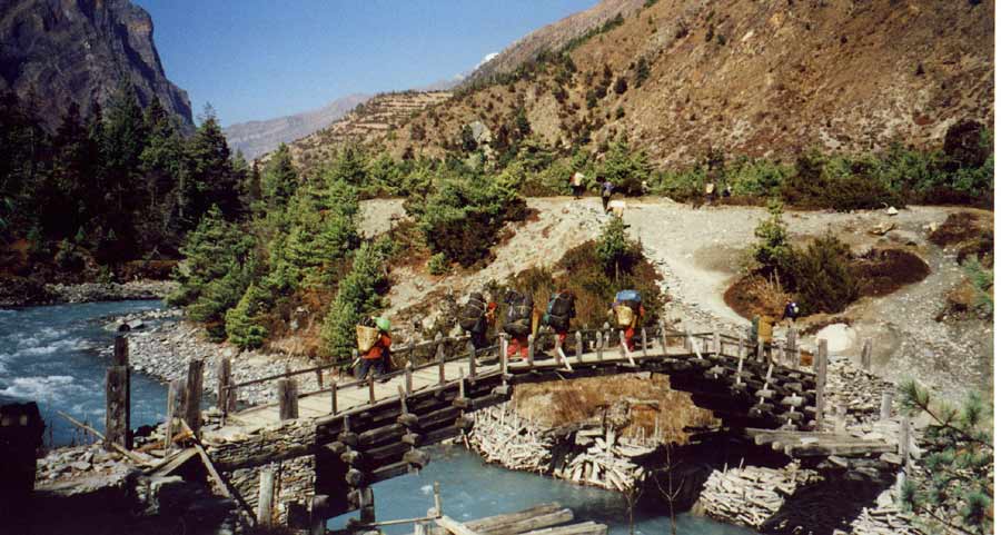
We enter the high valley of Manang and cross the river Marsyangdi to climb up to
the high route. Most tourists follow the river upstream, the villages and views
are absolutely worth the small extra effort.
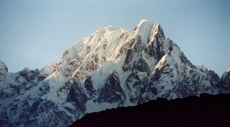
The enchanged Marsyangdi valley with Chulu Far East in the background.
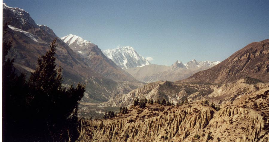
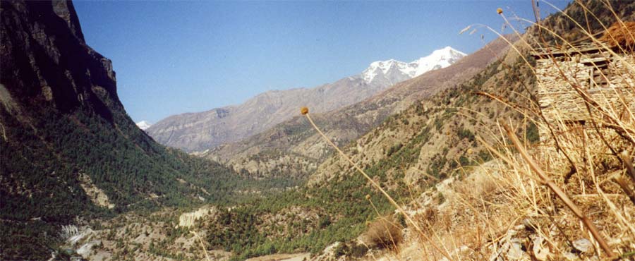
The organ-pipe erosion of the valley is contrasting nicely with the forests and
huge mountain range of the Annapurnas.
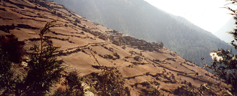
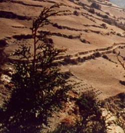
The three villages are depending on agriculture more than trade. Terracing the
steep hillsides is almost impossible, but it is flat enough to grow potatoes and
grain.
Manaslu: Bimthang - Annapurna Circuit - Chulu Camp
Bimthang - Annapurna Circuit - Chulu Waterfall camp
Bimthang - Soti Khola (Day 18)
Nice morning views again; the range to the north has some fog drifting in front of it, making the mountains more impressive. Another 360° panorama. It was cloudy since yesterday evening, and a cold wind destroys all hopes for 'post-pass-warm-holidays'. The fire in the lodge is the best spot to wait for the fog to burn off, and the two girls are fun, though I speak no Nepali and feel a bit stupid.
I would like to walk up to the green glacial lake, but it is not a 5-minutes walk away as we were told. Nevertheless, the views of the glacier from top of the moraine are nice. Two huge peaks of the Kampung Himal rise above the clouds, but haze blurs the views. A white river flows down in a riverbed of white-pebbles, giving it the name Dudh Khola (dud means milk in Nepali).
We cross the bed of the old glacier and enter an enchanting forest on the other side. Huge firs with moss are predominant at first, but the variety of plants grows as we get further down - bushes, ferns, and deciduous trees. The mountain views are fantastic and much better than I expected it. Manaslu stretches high into the sky, the glaciers and moraines come down a long way and end just above the steep wall of the Dudh Khola valley. The mountain looks very different from here, instead of an even pyramid it seems to be a huge square with the two peaks sitting in the middle. It is worth going slowly, the views are so stunning that I stop often and watch for a long time. The hills in front of the Manaslu range add to the diversity of gray glaciers and white summits, a green hill with dark trees stands next to a brown hill with white birches. The peaks slowly disappear in the haze, and we get further down in the valley that becomes narrower. Walking in forests is pleasant after the barren high country. It is overload for the senses: all the colors, fragrances and sounds are overwhelming after days of brown and gray tones where the howling of wind was the only noise. In two days I will probably wish I were back above the timberline, but right now it is a real joy.
The afternoon is a bit dull, but luckily short. Grey clouds hang in the valley, it gets chilly soon. Having crossed the pass was a reminder that this trip will 'soon' be finished, and at camp 'post-pass-depression' comes over me. Luckily it goes away quickly after taking a luke-warm shower and spending an afternoon with biscuits and tea over a good book.
Soti Khola - Danagyu (Day 19)
We continue to follow the Dud Khola down to the Marsyangdi valley. There we will hit the popular Annapurna Circuit. The creek slowly turns its color into a blueish gray, at first the walk is interesting because of the different plants and the mountain views, but then its get a bit boring compared to other days. The gorge allows for little cultivation, so the number of houses is small. Except for a guesthouses they are all deserted, people moved back to Tilje or maybe even further down to Pokhara or Kathmandu as winter will arrive soon.
After two hours I get to Tilje, the first larger village since Samdo. The houses are quite elaborate, more wood is used as building material and people pay more attention to its appearance. Landslides and rockfall have destroyed the last part of the trail. Just afterwards a bridge leads to Thonje, a town with a large school just opposite Dharapani. Ang Dami is waiting there, he went ahead yesterday to sort out the gear and organize things for the next week, and our climb. Some of the loads are left behind and will be picked up on the way to Besisahar in a week. Our liaison officer Manjul is leaving here, he was the most pleasant officer I met so far, and he seemed to enjoy the trek. Sometimes these officers are in a strange position, shunned by tourists and the crew, but luckily this was not the case here.
We are on one of the most popular trails in Nepal now. This part of our trek is a much bigger letdown than I expected; the wide trail is littered and full of horseshit, the scenery is not especially nice and the weather not fine either. We pass a few villages with endless shops and guesthouses and stop in Danagyu. Staying in a lodge feel like betrayal, although it is nice and clean it feels like an unnecessary luxury. The crazy drunk guy kind of fits into this day. Somehow such a letdown day belongs to trekking, it helps to appreciate all the other great days we enjoyed and will make the ones ahead of us even better.
Danagyu - Bratang (Day 20)
The walk in the morning is much nicer than the one yesterday afternoon. We follow the river upstream through forests; the scenery is familiar to me, but if you are here for the first time it is very impressive, at least the tourists I meet on the way are just excited.
When the first peaks of the Annapurna massif rise above the forest, it becomes more interesting, the scenery changes more often now. Some landslides took out large parts of the trail, but now the path is in good condition again. Shortly before Kudo, a nice-looking Tibetan village, the views of Annapurna II are fantastic. A very narrow gorge branches off to the east and goes to Nar, a totally restricted area with some remote villages.
We have met some tourists, but not the hordes of ignorants that you would expect on this popular trek. The stores in Chame have an incredibly selection, you can get everything here. It is a culture shock, but a pleasant one. We all stock up on chocolate, Tang, and every other snack you can think of. The village girls seem to like me and we exchange many, many smiles.
Two portions of fantastic dal baht later we start for a long afternoon. After climbing uphill for some time I meet a monk and am surprised that he speaks Tibetan. An old couple from the village joins us - I feel like the worst part of the Annapurna Circuit is behind us now.
It gets cold after the sun disappears early, making this a day where the purpose of walking is to arrive somewhere and you don't do it just because it is fun. Nonetheless, this day was much more pleasant than yesterday. The views were nice, the scenery was interesting and the villages less out of place. After three weeks of walking I usually have a day or two when I do not enjoy trekking as much as on the other days, but tomorrow I should be fine again.
When we reach Bratang I realize that I camped here about ten years ago. The 'town' still looks a bit poorish from the outside. But the house of the didi's family is very comfortable. She is a 19-year old Gurung girl and has to do all the work since the others are not a big help, This leaves little time for conversation, which is a pity because she is really cool. Originally the village was founded by Tibetans resistance fighters that were attacking Chinese troops from the Nepali side of the border. Nothing reminds me of that past, though.
Bratang - Upper Pisang - Ghyaru (Day 21)
Most people had a hard time sleeping because horses with bells kept passing just below the lodge till late in the night. I usually wake up easily, but am happy to get up as usual half an hour before breakfast tea. The ridge of the Annapurna range is reaching above the timberline in the form of a narrow orange stripe between the blue sky and the green forest.
The trail is chiseled in a vertical rock face, a very promising start for today. Below the steep smooth curved rockface of Paungda Danga we cross the river and after an hour in a pine forest more and more mountains become visible. Shortly before Pisang we overlook the wide valley with its organ-pipe erosion and white peaks higher up. It was a nice walk in the shade of the forest, but I am happy that we take the high trail now and climb up to Upper Pisang after crossing the blue Marsyangdi river. The fort-like houses with Chulu East behind are a great view. Because most tourists take the lower trail, the town kept its authentic look and not a single brightly painted shop hurts the eye. Most people have left for the lower valleys, making the walk around the village very short. A new monastery is being built, though the old one looks very nice. The ground floor is used only a few times a year, most notably for Losar dances (Tibetan New Year festival in February). The first floor is a gallery with views down to the dancing room. Above it is the gompa, it is rather small and filled with modern bauble and souvenirs from Bangkok that do not fit in.
After a short descent we are back in the forest and pass a long mani wall. High above on the right is a white monastery. It looks like a strenuous and long climb, but once you get going, zigzagging up the hill is easy and fast. When I reach the three white chortens I am surprised to see not only the gompa but also a large village. I thought Ghyaru was much further away.
The village is similar to Upper Pisang, but the houses are built together much closer and the town seems very 'untouristy'. It is fun to walk through the narrow alleys looking for interesting things. The gompa on the upper part of the town is locked and while looking for the caretaker I hear the murmuring of people praying. I climb a long and steep ladder - of course only after unsuccessfully calling for somebody, I am trying to be polite and also I do not want to meet a snappish watchdog up there. In a small building on the roof are a few monks and a nun I met in Chame reciting texts. They read them from scripts, everybody seems to have a different book. It is probably also a ceremony for protection and a whole liturgy is being read.
When I want to go back down I find it almost impossible to use the ladder. It is too steep, the notches are too small - I would probably lose my balance and fall down 10 feet to the ground. Luckily the house owner sees me and lets me climb a small fence on the roof, so I can take a regular staircase and walk to the guesthouse. By now everybody has arrived and we decide to stay in the nice lodge because there is no campground. That is why most groups take the lower trail, and for some strange reason even individual trekkers prefer the lower route.
I walk up to the gompa an hour later and an older man is there to let me in. The monastery is much nicer than the one in Upper Pisang, but the caretaker is not very knowledgeable. After answering many questions in Tibetan he explains that the Panchen Lama is the head of the Nyingma sects - which casts doubts on all the previous answers he has given. On the way back I meet the Tenzing, Ang Dami and Bharat, and walk around the village with them. It is their first time in this village, and they say 'now we are tourists, too, and want to look at everything'. That is really cool, and after twenty minutes Bharat finds a nice house where we can warm up in the kitchen.
The family is originally from Tibet but fled in the 1960s and settled down here. One of the children lives in Germany, but I do not know him (it's a small world and it wouldn't have been surprising to have met his son). It is great to sit around the fire and talk to the couple and their two grand-children. When I run out of Tibetan, the conversation switches into Nepali and somebody translates. These 'kitchen-experiences' are new to me, spending evenings like that has made the trek much more interesting because the time in camp is usually not very exciting. Of course it would be more fun without any language barrier at all, but I am doing fine with a little smalltalk and often somebody can do the translation. After some cups of butter tea we say good-bye, and I get back to the lodge.
It is rather chilly, even inside the lodge, so after hot soup it is a good idea to go to bed early.
Ghyaru - Nawal - Waterfall camp (Day 22)
I hoped for a fantastic sunrise - I still remember getting up early in Braga some years ago - but it is freezing and not worth it: Sunrise passes without illuminating the mountains. I guess we were really spoiled with fine weather if I am complaining about things like that. The Annapurna massif does look fantastic, one huge peak is connected to the next one by a fine ridge.
The village looks very nice in the morning sun, steep barren fields surround it and the white Pisang Peak rises just behind. Many people think it is the easiest trekking peak in the area, after looking closely at its steep flank just before the summit I really, really hope that they are wrong. I want Chulu Far East not to be any steeper. Prayerflags higher up indicate a religious monument, but I am not too keen on exploring and stay on the main path. The mountains are incredible, Annapurna II, IV, III and Gangapurna are very close, further north is Tilicho. In addition to the mountains we see the rugged Marsyangdi valley with forests, washed out canyons and the barren mountains at the far end where Thorung La crosses over to Muktinath. To the south is the sheer carved rockface of Paungda Danga, Lamjung Himal and at the horizon is a peak that resembles Himal Chuli.
On the traverse to Nawal we pass some girls selling biscuits and cokes up here in the middle of nowhere. Hopefully they are is busier in the high season, only few trekkers take this trail and they are probably not craving for biscuits. A chorten announces the village; situated on a flat valley confined by organ-pipe eroded walls and high peaks in the background, it is one of the many fantastic views of today. The ridge of Chulu East does not look too difficult, but I guess mountains always look easy from miles away. The old gompa is not very interesting, it has been replaced by a newer one that also serves as monastic school, and maybe all the nice statues and thangkas were moved to there.
We leave the Annapurna Circuit now and take the trail to Chulu. On the way there we pass a village that is on no map, it seems completely deserted but the colorful prayerflags indicate that at least three houses are still inhabited. Then we pass the most beautiful chortens of the entire trek, they are very well-kept and built in a style often found north of Muktinath: white washed with paintings and red wooden frames. In a little sidevalley lies the village Chulu, the creek that flows by comes from two waterfalls further up where we will put up our camp. On the way down I hear much laughter, it comes from young monks who are carrying large trunks of firewood to their school. The large building is a branch of a Kagyü monastery in Kathmandu. Hopefully we will have an extra day before flying out and I can spend some time here.
The lunchspot is great once again; a creek, red bushes and birch trees in front of the few Chulu houses with large yellow haystacks on their roofs. A canyon with firs on its top rises beyond the village, the steep flanks of Annapurna III and the white pyramid-shaped summit of Gangapurna are in the background. The light is not very good, otherwise this would be a potential 'picture of the year'.
After a good lunch at this lovely spot it is just one more hour to waterfall camp. The hike along the Chegaji Khola is lovely, the steep and barren hills and snowridges are quite a contrast to the pleasant atmosphere in the enchanting forest down here. The porters are a bit grumpy because we do not stop at the first campsite and go on for a little longer until we camp close to the two partly frozen waterfalls. But their faces light up when they see the small stone hut and a huge dry tree in the fireplace.
The sunset on the Annapurnas is a fantastic view and a reminder to put on some warm clothes. It is really chilly soon and we all gather round the large bonfire. The group will be splitting tomorrow: Dagmar, Tracey and Lizzy will go down to Braga; Dana, John, Tom, Jamie and I attempt the peak and will set up camp at around 5'000m. Spending an evening around a cozy campfire is a perfect end of a great trekking. Somehow the group never became close-knitted, but we had a nice time together and avoided any fights or arguments. For some the novelty has worn off after three weeks and grumpy moments happen more often than in the beginning. It is -10° C, but the cold is driven away by warm clothes, the fire, hot soup and excellent dal baht. And once you are in the sleeping bag you are warm anyway. Well, except for the damned 'latrine-calls'. My equipment-list is almost perfect but still has room for improvement: Tang powder, green tea leaves and a pee bottle will definitely be on the next version.
|
Summary Part 5:
After crossing the moraine below Bimthang we enter a dense forest. Walking in forests is pleasant after the barren high country. It is overload for the senses: all the colors, fragrances and sounds are overwhelming after days of brown and gray tones where the howling of wind was the only noise. Manaslu disappears as we get further down in the valley. In Danagyu we join the most popular (and populated) trail in Nepal. Needless to say the first day comes as culture shock. Luckily we take the high trail with less tourists and enjoy atmosphere in vallages and the stunning views. The barren Marsyangdi valley with some pleasant pine forests are contrasted by the huge peaks of the Annapurna range. We leave the Annapurna trail and head to base camp of Chulu Far East. On the way we pass the pictuersque Chulu village: a creek, red bushes and birch trees in front of the few houses that have large yellow haystacks on their roofs. A canyon with firs on its top rises beyond the village, the steep flanks of Annapurna III and the white pyramid-shaped summit of Gangapurna are in the background. The hike along the Chegaji Khola is lovely, the steep and barren hills and snowridges are quite a contrast to the pleasant atmosphere in the enchanting forest. |